Portal:World
The World Portal


The world is the totality of entities, the whole of reality, or everything that exists. The nature of the world has been conceptualized differently in different fields. Some conceptions see the world as unique, while others talk of a "plurality of worlds". Some treat the world as one simple object, while others analyze the world as a complex made up of parts.
In scientific cosmology, the world or universe is commonly defined as "the totality of all space and time; all that is, has been, and will be". Theories of modality talk of possible worlds as complete and consistent ways how things could have been. Phenomenology, starting from the horizon of co-given objects present in the periphery of every experience, defines the world as the biggest horizon, or the "horizon of all horizons". In philosophy of mind, the world is contrasted with the mind as that which is represented by the mind.
Theology conceptualizes the world in relation to God, for example, as God's creation, as identical to God, or as the two being interdependent. In religions, there is a tendency to downgrade the material or sensory world in favor of a spiritual world to be sought through religious practice. A comprehensive representation of the world and our place in it, as is found in religions, is known as a worldview. Cosmogony is the field that studies the origin or creation of the world, while eschatology refers to the science or doctrine of the last things or of the end of the world.
In various contexts, the term "world" takes a more restricted meaning associated, for example, with the Earth and all life on it, with humanity as a whole, or with an international or intercontinental scope. In this sense, world history refers to the history of humanity as a whole, and world politics is the discipline of political science studying issues that transcend nations and continents. Other examples include terms such as "world religion", "world language", "world government", "world war", "world population", "world economy", or "world championship". (Full article...)
Selected articles -
-


Nuclear proliferation is the spread of nuclear weapons to additional countries, particularly those not recognized as nuclear-weapon states by the Treaty on the Non-Proliferation of Nuclear Weapons, commonly known as the Non-Proliferation Treaty or NPT. Nuclear proliferation occurs through the spread of fissile material, and the technology and capabilities needed to produce it and to design and manufacture nuclear weapons. In a modern context, it also includes the spread of nuclear weapons to non-state actors. Proliferation has been opposed by many nations with and without nuclear weapons, as governments fear that more countries with nuclear weapons will increase the possibility of nuclear warfare (including the so-called countervalue targeting of civilians), de-stabilize international relations, or infringe upon the principle of state sovereignty. Conversely, supporters of deterrence theory argue that controlled proliferation decreases conflict rates via nuclear peace.
Nuclear weapons were initially researched during World War II, jointly by the United States, United Kingdom and Canada, and separately by Germany, Japan, the Soviet Union, and France. The United States was the first and is the only country to have used a nuclear weapon in war, when it used two bombs against Japan in August 1945. After surrendering, Germany and Japan ceased to be involved in any nuclear weapon research. A nuclear arms race followed, with further countries developing and testing nuclear weapons. The US primarily competed with the Soviet Union, which carried out their first test in 1949. Seven other countries developed nuclear weapons during the Cold War. The UK and France, both NATO members, developed fission and fusion weapons throughout the 1950s, and 1960s, respectively. China developed both against the backdrop of the Sino-Soviet split. (Full article...) -
The Eastern world, also known as the East or historically the Orient, is an umbrella term for various cultures or social structures, nations and philosophical systems, which vary depending on the context. It most often includes Asia, the Mediterranean region and the Arab world, specifically in historical (pre-modern) contexts, and in modern times in the context of Orientalism. Occasionally, the term may also include countries in Eastern Europe and the Balkans. The Eastern world is often seen as a counterpart to the Western world.
The various regions included in the term are varied, hard to generalize, and do not have a single shared common heritage. Although the various parts of the Eastern world share many common threads, most notably being in the "Global South", they have never historically defined themselves collectively. The term originally had a literal geographic meaning, referring to the eastern part of the Old World, contrasting the cultures and civilizations of Asia with those of Europe (or the Western world). (Full article...) -

The Global Positioning System (GPS) is a satellite-based hyperbolic navigation system owned by the United States Space Force and operated by Mission Delta 31. It is one of the global navigation satellite systems (GNSS) that provide geolocation and time information to a GPS receiver anywhere on or near the Earth where signal quality permits. It does not require the user to transmit any data, and operates independently of any telephone or Internet reception, though these technologies can enhance the usefulness of the GPS positioning information. It provides critical positioning capabilities to military, civil, and commercial users around the world. Although the United States government created, controls, and maintains the GPS system, it is freely accessible to anyone with a GPS receiver. (Full article...) -
The World Bank Group (WBG) is a family of five international organizations that make leveraged loans to developing countries. It is the largest and best-known development bank in the world and an observer at the United Nations Development Group. The bank is headquartered in Washington, D.C., in the United States. It provided around $98.83 billion in loans and assistance to "developing" and transition countries in the 2021 fiscal year. The bank's stated mission is to achieve the twin goals of ending extreme poverty and building shared prosperity. Total lending as of 2015 for the last 10 years through Development Policy Financing was approximately $117 billion. Its five organizations have been established over time:- International Bank for Reconstruction and Development (IBRD), 1944
- International Development Association (IDA), 1960
- International Finance Corporation (IFC), 1956
- International Centre for Settlement of Investment Disputes (ICSID), 1965
- Multilateral Investment Guarantee Agency (MIGA), 1988
-

Photograph of three Douglas World Cruiser aircraft on a beach, Alaska, 1924. New Orleans is in the foreground.
The first aerial circumnavigation of the world was completed in 1924 by four aviators from an eight-man team of the United States Army Air Service, the precursor of the United States Air Force. The 175-day journey from April to September covered over 26,345 miles (42,398 km). The team generally traveled east to west, around the northern Pacific Rim, through to South Asia and Europe and back to Seattle's Sand Point Airfield in the United States. Airmen Lowell H. Smith and Leslie P. Arnold, and Erik H. Nelson and John Harding Jr. made the trip in two single-engined open-cockpit Douglas World Cruisers (DWC) configured as floatplanes for most of the journey. Lead aircraft Chicago, and the New Orleans completed the expedition. Four more flyers in two additional DWC began the journey but their aircraft crashed or were forced down. All airmen survived. They were awarded the Distinguished Service Medal, and the flight won the Mackay Trophy aviation award for 1924. (Full article...) -

World War II or the Second World War (1 September 1939 – 2 September 1945) was a global conflict between two coalitions: the Allies and the Axis powers. Nearly all of the world's countries participated. Tanks and aircraft played major roles, the latter enabling the strategic bombing of cities and delivery of the only nuclear weapons used in war. World War II is the deadliest conflict in history, causing the death of over 60 million people. Millions died in genocides, including the Holocaust, and by massacres, starvation, and disease. After the Allied victory, Germany, Austria, Japan, and Korea were occupied, and German and Japanese leaders were tried for war crimes.
The causes of World War II included unresolved tensions in the aftermath of World War I, and the rise of fascism in Europe and militarism in Japan. Key events preceding the war included Japan's invasion of Manchuria in 1931, the Spanish Civil War, the outbreak of the Second Sino-Japanese War in 1937, and Germany's annexations of Austria and the Sudetenland. World War II is generally considered to have begun on 1 September 1939, when Nazi Germany, under Adolf Hitler, invaded Poland, after which the United Kingdom and France declared war on Germany. Poland was also invaded by the Soviet Union in mid-September, and was partitioned between Germany and the Soviet Union under the Molotov–Ribbentrop Pact. In 1940, the Soviet Union annexed the Baltic states and parts of Finland and Romania, while Germany conquered Norway, Denmark, Belgium, Luxembourg, and the Netherlands. After the fall of France in June 1940, the war continued mainly between Germany, now assisted by Fascist Italy, and the British Empire/British Commonwealth, with fighting in the Balkans, Mediterranean, and Middle East, East Africa, the aerial Battle of Britain and the Blitz, and the naval Battle of the Atlantic. By mid-1941, Yugoslavia and Greece had also been defeated by Axis countries. In June 1941, Germany invaded the Soviet Union, opening the Eastern Front. (Full article...) -

The offices of the United Nations in Geneva (Switzerland), which is the city that hosts the highest number of international organizations in the world
An international organization, also called an intergovernmental organization (IGO) or an international institution, is an association of states established by a treaty or other type of instrument governed by international law to pursue the common aim of its member states. An IGO possesses its own legal personality separate from its member states and can enter into legally binding agreements with other IGOs or with other states. The United Nations, Council of Europe, African Union, Organization of American States, North Atlantic Treaty Organization, Mercosur, and BRICS are examples of IGOs. International organizations are composed of primarily member states, but may also include other entities, such as other international organizations, firms, and nongovernmental organizations. Additionally, entities may hold observer status. Under international law, although treaties are typically between states, intergovernmental organizations also have the capacity to enter into treaties. The traditional view was that only states were subjects of international law, but with the founding of the United Nations, that view expanded to include intergovernmental organizations.
Within the international relations literature, international organizations facilitate cooperation between states by reducing transaction costs, providing information, making commitments more credible, establishing focal points for coordination, facilitating the principle of reciprocity, extending the shadow of the future, and enabling interlinkages of issues, which raises the cost of noncompliance. States may comply with the decisions of international organizations, even when they do not want to, for rational cost-benefit calculations (to reap concrete rewards of future cooperation and avoid punishment) and normative reasons (social learning and socialization). (Full article...)
.jpg)
General images -
-
 Trilobites first appeared during the Cambrian period and were among the most widespread and diverse groups of Paleozoic organisms. (from History of Earth)
 -
 Dinosaurs were the dominant terrestrial vertebrates throughout most of the Mesozoic (from History of Earth)
 -
 Notre-Dame de Paris, France
 -
 A computer-generated image mapping the prevalence of artificial satellites and space debris around Earth in geosynchronous and low Earth orbit (from Earth)
 -

-
 An artist's impression of ice age Earth at glacial maximum. (from History of Earth)
 -
 A composite image of Earth, with its different types of surface discernible: Earth's surface dominating Ocean (blue), Africa with lush (green) to dry (brown) land and Earth's polar ice in the form of Antarctic sea ice (grey) covering the Antarctic or Southern Ocean and the Antarctic ice sheet (white) covering Antarctica. (from Earth)
 -

-
 13th-century French historiated initial with the three classes of medieval society: those who prayed (the clergy), those who fought (the knights), and those who worked (the peasantry)
 -
 An animation of the changing density of productive vegetation on land (low in brown; heavy in dark green) and phytoplankton at the ocean surface (low in purple; high in yellow) (from Earth)
 -
 The replicator in virtually all known life is deoxyribonucleic acid. DNA is far more complex than the original replicator and its replication systems are highly elaborate. (from History of Earth)
 -
.jpg) Vitruvian Man, c. 1490 by Leonardo da Vinci, epitomizes the advances in art and science seen during the Renaissance. (from History of Earth)
Vitruvian Man, c. 1490 by Leonardo da Vinci, epitomizes the advances in art and science seen during the Renaissance. (from History of Earth) -

-
 Pangaea was a supercontinent that existed from about 300 to 180 Ma. The outlines of the modern continents and other landmasses are indicated on this map. (from History of Earth)
 -
 Graph showing range of estimated partial pressure of atmospheric oxygen through geologic time (from History of Earth)
 -
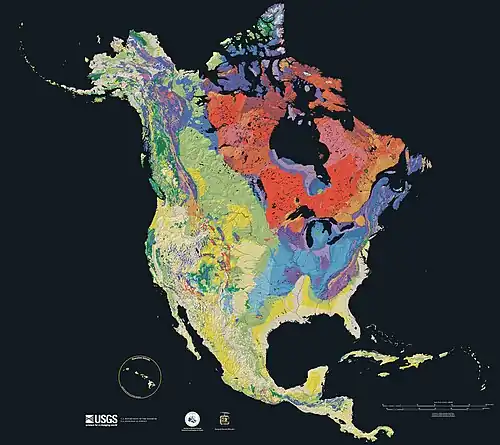 Geologic map of North America, color-coded by age. From most recent to oldest, age is indicated by yellow, green, blue, and red. The reds and pinks indicate rock from the Archean.
 -
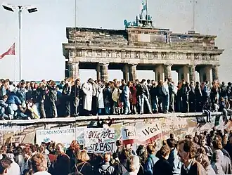 Fall of the Berlin Wall, 1989
 -
 Pale orange dot, an impression of Early Earth, featuring its tinted orange methane-rich early atmosphere (from Earth)
 -

-
 Taj Mahal, Mughal Empire, India
 -
 The Colosseum in Rome (from Human history)
 -
 Earth's axial tilt causing different angles of seasonal illumination at different orbital positions around the Sun (from Earth)
 -
 Florence, birthplace of the Italian Renaissance
 -

-
 Yggdrasil, an attempt to reconstruct the Norse world tree which connects the heavens, the world, and the underworld. (from World)
 -
 One of the eleven Rock-hewn Churches of Lalibela constructed during the Zagwe dynasty in Ethiopia (from Human history)
 -
 A view of Earth with its global ocean and cloud cover, which dominate Earth's surface and hydrosphere; at Earth's polar regions, its hydrosphere forms larger areas of ice cover. (from Earth)
 -
 A pillar at Neolithic Göbekli Tepe
 -
 Artist's impression of the enormous collision that probably formed the Moon (from History of Earth)
 -

-

-
 Angkor Wat temple complex, Cambodia, early 12th century
 -
The pale orange dot, an artist's impression of the early Earth which might have appeared orange through its hazy methane rich prebiotic second atmosphere. Earth's atmosphere at this stage was somewhat comparable to today's atmosphere of Titan. (from History of Earth)
-
 A depiction of the early Solar System's protoplanetary disk from which Earth and other Solar System bodies were formed (from Earth)
 -
 Lithified stromatolites on the shores of Lake Thetis, Western Australia. Archean stromatolites are the first direct fossil traces of life on Earth. (from History of Earth)
 -
 Earth's land use for human agriculture in 2019 (from Earth)
 -
 Battle during the 1281 Mongol invasion of Japan
 -
 Chennakesava Temple, Belur, India
 -
 Cross-section through a liposome (from History of Earth)
 -
 Artist's rendition of an oxinated fully-frozen Snowball Earth with no remaining liquid surface water. (from History of Earth)
 -
 Pillar erected by Ashoka, a Mauryan Emperor in India
 -
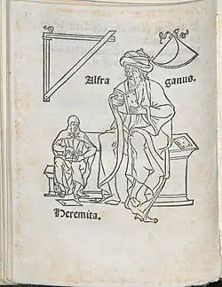 Portrait of Alfraganus in the Compilatio astronomica, 1493. Islamic astronomers began just before the 9th century to collect and translate Indian, Persian and Greek astronomical texts, adding their own astronomy and enabling later, particularly European astronomy to build on. Symbolic for the post-classical period, a period of an increasing trans-regional literary culture, particularly in the sciences, spreading and building on methods of science. (from Human history)
 -
 Earth's night-side upper atmosphere appearing from the bottom as bands of afterglow illuminating the troposphere in orange with silhouettes of clouds, and the stratosphere in white and blue. Next the mesosphere (pink area) extends to the orange and faintly green line of the lowest airglow, at about one hundred kilometers at the edge of space and the lower edge of the thermosphere (invisible). Continuing with green and red bands of aurorae stretching over several hundred kilometers. (from Earth)
 -
 A composite image of artificial light emissions at night on a map of Earth (from Earth)
 -
 Artist's impression of Earth during the later Archean, the largely cooled planetary crust and water-rich barren surface, marked by volcanoes and continents, features already round microbialites. The Moon, still orbiting Earth much closer than today and still dominating Earth's sky, produced strong tides. (from History of Earth)
 -
 Benin Bronze head from Nigeria
 -
 Earth's history with time-spans of the eons to scale. Ma means "million years ago", Ga means "billion years ago". (from History of Earth)
 -
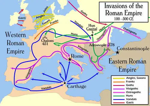 European migrations by mostly Germanic peoples, 2nd–6th centuries (from Human history)
 -
 Earth's western hemisphere showing topography relative to Earth's center instead of to mean sea level, as in common topographic maps (from Earth)
 -
 Machu Picchu, Inca Empire, Peru
 -
 Artist's conception of Hadean Eon Earth, when it was much hotter and inhospitable to all forms of life. (from History of Earth)
 -
.png) Cuneiform inscription, eastern Turkey
Cuneiform inscription, eastern Turkey -
.jpeg) Standing Buddha from Gandhara, 2nd century CE
Standing Buddha from Gandhara, 2nd century CE -
 A view of Earth with different layers of its atmosphere visible: the troposphere with its clouds casting shadows, a band of stratospheric blue sky at the horizon, and a line of green airglow of the lower thermosphere around an altitude of 100 km, at the edge of space (from Earth)
 -

-
 A map of heat flow from Earth's interior to the surface of Earth's crust, mostly along the oceanic ridges (from Earth)
 -
 Ming dynasty section, Great Wall of China
 -
 COVID-19 pandemic, 2020 (from Human history)
 -
 Change in average surface air temperature and drivers for that change. Human activity has caused increased temperatures, with natural forces adding some variability. (from Earth)
 -
 Japanese depiction of a Portuguese carrack, a result of globalizing maritime trade
 -
 A banded iron formation from the 3.15 Ga Moodies Group, Barberton Greenstone Belt, South Africa. Red layers represent the times when oxygen was available; gray layers were formed in anoxic circumstances. (from History of Earth)
 -
.jpg) The first airplane, the Wright Flyer, flew on 17 December 1903.
The first airplane, the Wright Flyer, flew on 17 December 1903. -
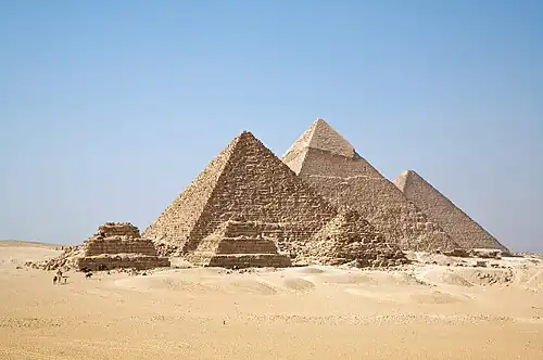 Great Pyramids of Giza, Egypt
 -
 Image of the physical world, captured by the Hubble Space Telescope (from World)
 -
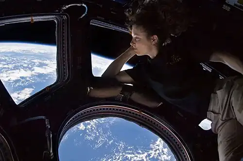 Tracy Caldwell Dyson, a NASA astronaut, observing Earth from the Cupola module at the International Space Station on 11 September 2010 (from Earth)
 -
 Chloroplasts in the cells of a moss (from History of Earth)
 -
 Olmec colossal head, now at the Museo de Antropología de Xalapa
 -

-
 Last Moon landing: Apollo 17 (1972)
 -
 An artist's rendering of a protoplanetary disk (from History of Earth)
 -

-
 Tiktaalik, a fish with limb-like fins and a predecessor of tetrapods. Reconstruction from fossils about 375 million years old. (from History of Earth)
 -
 A schematic view of Earth's magnetosphere with solar wind flowing from left to right (from Earth)
 -
 A 580 million year old fossil of Spriggina floundensi, an animal from the Ediacaran period. Such life forms could have been ancestors to the many new forms that originated in the Cambrian Explosion. (from History of Earth)
 -
 Artist's conception of Devonian flora (from History of Earth)
 -
.svg.png)
-
An impression of the Archean, the eon after Earth's formation, featuring round stromatolites, which are early oxygen-producing forms of life from billions of years ago. After the Late Heavy Bombardment, Earth's crust had cooled, its water-rich barren surface is marked by continents and volcanoes, with the Moon still orbiting Earth half as far as it is today, appearing 2.8 times larger and producing strong tides. (from Earth)
-
 Artist's impression of a Hadean landscape with the relatively newly formed Moon still looming closely over Earth and both bodies sustaining strong volcanism. (from History of Earth)
 -

-
 A reconstruction of Pannotia (550 Ma). (from History of Earth)
 -
 A reconstruction of human history based on fossil data. (from History of Earth)
 -
 Obelisk of Axum, Ethiopia
 -
 Carving of Persian and Median soldiers, Persepolis, Achaemenid Empire, 5th century BCE
 -
 Satellite time lapse imagery of Earth's rotation showing axis tilt (from Earth)
 -
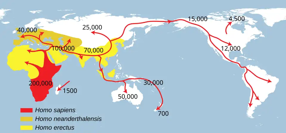 Successive dispersals of Homo erectus (yellow), Homo neanderthalensis (ochre) during Out of Africa I and Homo sapiens (red, Out of Africa II), with the numbers of years since they appeared before present. (from Human history)
 -

Megacities of the world -
.jpg)
New York, often called New York City (NYC), is the most populous city in the United States. It is located at the southern tip of New York State on New York Harbor, one of the world's largest natural harbors. The city comprises five boroughs, each coextensive with its respective county. It is the geographical and demographic center of both the Northeast megalopolis and the New York metropolitan area, the largest metropolitan area in the United States by both population and urban area. New York is a global center of finance and commerce, culture, technology, entertainment and media, academics and scientific output, the arts and fashion, and, as home to the headquarters of the United Nations, international diplomacy.
With an estimated population in July 2024 of 8,478,072, distributed over 300.46 square miles (778.2 km2), the city is the most densely populated major city in the United States. New York City has more than double the population of Los Angeles, the country's second-most populous city. Over 20.1 million people live in New York City's metropolitan statistical area and 23.5 million in its combined statistical area as of 2020, both the largest in the U.S. New York City is one of the world's most populous megacities. The city and its metropolitan area serve as the premier gateway for legal immigration to the United States. An estimated 800 languages are spoken in New York City, making it the most linguistically diverse city in the world. The New York City metropolitan region is home to the largest foreign-born population of any metropolitan region in the world, approximately 5.9 million as of 2023. (Full article...)
Did you know -

- ... that Hungarians Gyula Bajó and Endre Hevizi, who went on to design stained glass for the Debre Libanos monastery, worked as labourers in a British pottery after the Second World War?
- ... that among the millions of prisoners of war murdered by the Germans during WWII there were also tens of thousands of their former allies, the Italians?
- ... that the Ferrari FF was, upon its release, the world's fastest four-seater car?
- ... that Thos. W. Ward Ltd. used camels and an elephant named Lizzie to replace horses during World War I?
- ... that the first dogs in space returned to Earth with a parachute?
- ... that the FogCam is believed to be the world's longest-running public webcam?
- ... that the tower of a North Dakota TV station was the world's tallest man-made structure from 1963 to 1974 and again from 1991 to 2008?
- ... that Mary Kahil, an Egyptian Christian mystic, cofounded one of the earliest women's movements in the Arab world?
Countries of the world -
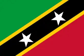
Saint Kitts and Nevis, officially the Federation of Saint Kitts and Nevis, is an island country located in the Caribbean consisting of the two islands of Saint Kitts and Nevis, in the Leeward Islands chain of the Lesser Antilles. With 261 square kilometres (101 sq mi) of territory, and roughly 48,000 inhabitants, it is the smallest sovereign state in the Western Hemisphere, in both area and population, as well as the world's smallest sovereign federation. The country is a Commonwealth realm, with Charles III as king and head of state.
The capital city is Basseterre, located on the larger island of Saint Kitts. Basseterre is also the main port for passenger entry (via cruise ships) and cargo. The smaller island of Nevis lies approximately 3 km (2 mi) to the southeast of Saint Kitts, across a shallow channel called The Narrows. (Full article...)
Eighth Wonder of the World is an unofficial title sometimes given to new buildings, structures, projects, designs or even people that are deemed to be comparable to the seven Wonders of the World. (Full article...)
Related portals
Protected areas of the world -
-
Protected areas of Estonia are regulated by the Nature Conservation Act (Estonian: Looduskaitseseadus), which was passed by the Estonian parliament on April 21, 2004, and entered into force May 10, 2004.
Overall Estonia has 15403 protected areas covering 21% of the country land and 18% of its marine and coastal territory, including 6 national parks: Lahemaa National Park, Karula National Park, Soomaa National Park,Vilsandi National Park, Matsalu National Park, and Alutaguse National Park (Full article...) -

Map of Georgia
The protected areas of Georgia cover almost one million acres (4,000 km2) of the state. These areas are managed by different federal and state level authorities and receive varying levels of protection. Some areas are managed as wilderness while others are operated with acceptable commercial exploitation. On the Federal level, Georgia contains 1 Biosphere Reserve, 15 National Park Service Managed Sites, 1 National Forest and 8 Wildlife Refuges. Georgia is home to 63 state parks, 48 of which are state parks and 15 that are National Historic Sites, and many state wildlife preserves, under the supervision of the Georgia Department of Parks and Recreation, a division of the Georgia Department of Natural Resources. (Full article...) -
Protected areas of Tasmania consist of protected areas located within Tasmania and its immediate onshore waters, including Macquarie Island. It includes areas of crown land (withheld land) managed by Tasmanian Government agencies as well as private reserves. As of 2016, 52% of Tasmania's land area has some form of reservation classification, the majority is managed by the Tasmania Parks and Wildlife Service (about 42% of total Tasmanian land area). Marine protected areas cover about 7.9% of state waters.
Within each classification of reserve there may be a variation of IUCN categories Australia is a signatory to the Convention of Biological Diversity and as such has obligations to report the status of its National Reserve System.IUCN provides on its website a prescription for activities consistent with the categorisation system. Changes made to the Nature Conservation Act 2002 in 2014 permit timber harvesting. These changes made in addition to the already established right to access minerals means that many of the IUCN categorisations assigned to individual reserves in Tasmania are no longer fit for purpose. In addition many reserves have had their reserve status downgraded from a class excluding timber harvesting and mineral extraction to ones where these activities are now permitted. This mis-application of the IUCN protected area categories needs to be remedied or the reserves protected land class under the Nature Conservation Act 2002 should be adjusted to reflect its currently assigned IUCN category. (Full article...) -
The Protected areas of Portugal (Portuguese: Áreas protegidas de Portugal) are classified under a legal protection statute that allows for the adequate protection and maintenance of biodiversity, while providing services for ecosystem that maintains the natural and geological patrimony. (Full article...)
-
Bihar is a state in East India. It is bounded by Uttar Pradesh to the west, Nepal to the north, West Bengal to the east and Jharkhand to the south. About 7% of the state is protected forest area. (Full article...)
-

The protected areas of Bhutan are its national parks, nature preserves, and wildlife sanctuaries. Most of these protected areas were first set aside in the 1960s, originally covering most of the northern and southern regions of Bhutan. Today, protected areas cover more than 42% of the kingdom, mostly in the northern regions. Protected areas also line most of Bhutan's international borders with China and India. (Full article...) -
The Australian Capital Territory as of 2014 contains 46 separate protected areas with a total land area of 1,302 km2 (503 sq mi) or 55.5% of the territory's area, and which managed by Territory and Municipal Services of the ACT government: (Full article...)
-

There are numerous parks throughout the sovereign island country of Singapore. This is a list of parks in Singapore that currently exist and have articles on Wikipedia. Under the National Parks Board Act 1996, the National Parks Board (NParks) maintains public parks, nature reserves, and national parks. Most of these parks are connected via the Park Connector Network (PCN) walking/running/cycling paths. (Full article...) -

Viru bog in Lahemaa National Park
Protected areas in Estonia are national parks, nature reserves and landscape protection areas (nature parks).
Estonia has five national parks, 167 nature reserves and 152 landscape conservation areas. In addition, there are 116 (118) protected areas with an old (Soviet-era) protection regulation and 537 parks. In total, 18.1% of Estonia are protected nature areas, with Lääne County having the highest percentage (32%) and Põlva County the lowest percentage of protected areas, about 9%. (Full article...) -

Mombacho Volcano Natural Reserve
The protected areas of Nicaragua are areas that have natural beauty or significance and are protected by Nicaragua. Nicaragua has 78 protected areas that cover 22,422 km2, about 17.3% of the nations landmass. The National System of Protected Areas (SINAP) is administered by the Ministry of the Environment and Natural Resources (MARENA). (Full article...) -
As of present, there are around 400 protected areas in Pakistan that are recognized by International Union for Conservation of Nature (IUCN). The total protected land area represents 13% of Pakistan's landmass as of 2020, The Government of Pakistan plans to increase it to at least 15% by 2023. As a signatory of the UN Convention on Biological Diversity, Pakistan is committed to expanding its protected areas to encompass 17% of its total territory by the year 2030. This ambitious goal aims to ensure the long-term conservation of nature, safeguard vital ecosystem services, and preserve the cultural values associated with these protected areas. (Full article...)
-
A list of protected areas of Yemen:
- Bura Community Protected Area
- Hawf National Reserve
- Dhamar Montane Plains Mahjur Traditional Reserve
- Jabal Bura Valley Forest National Park
- Ras Isa Marine Park
- Socotra Island Protected Area
- Zuqur Islands Marine National Park
- Bura Community Protected Area
-
Protected areas of Sri Lanka are administrated by Department of Forest Conservation and Department of Wildlife Conservation of Sri Lanka.There are 501 protected areas in Sri Lanka. The protected areas that fall under supervision of the Department of Forest Conservation include forests defined in National Heritage Wilderness Area Act in 1988, forest reservations, and forests managed for sustainability. Sinharaja Forest Reserve is an example for a National Heritage forest (it is also a World Heritage Site). There are 32 forests categorized as conservation forests including Knuckles Mountain Range. Strict nature reserves, national parks, nature reserves, forest corridors, and sanctuaries recognized under the Flora and Fauna Protection Ordinance are managed by Department of Wildlife Conservation. Total of all protected areas is 1,767,000 ha. Protected areas in Sri Lanka account for 26.5 percent of the total area. This is a higher percentage of protected areas than in all of Asia and much of the World. (Full article...)
-
.jpg)
Llyn y Fan Fach in the Brecon Beacons, one of Wales's three national parks
Wales, a country that is part of the United Kingdom, contains protected areas under various designations. The largest designation by land area is Wales's three national parks, followed by the five Areas of Outstanding Natural Beauty (sometimes collectively the "Designated Landscapes of Wales").
Among these protected areas is Snowdonia (Eryri), Wales's first and the UK's third designated national park, and the Gower AONB covering parts of the Gower Peninsula being both Wales's and the UK's first Area of Outstanding Natural Beauty (AONB), as well as smaller designations. (Full article...) -
Forests in the state of Himachal Pradesh (northern India) currently cover an area of nearly 37,939 square kilometres (14,648 sq mi), which is about 68.16% of the total land area of the state. The forests were once considered to be the main source of income of the state and most of the original forests were clear felled. The emphasis has shifted, however, from exploitation to conservation. The state government aims to increase forest cover to 50% of the total land area. There have been various projects, including the establishment of protected areas such as National Parks, designed to preserve and expand the forests. (Full article...)
Selected world maps
-
 Mollweide projection of the world
 -
 Time zones of the world
 -
 United Nations Human Development Index map by country (2016)
 -
 Only a few of the largest large igneous provinces appear (coloured dark purple) on this geological map, which depicts crustal geologic provinces as seen in seismic refraction data
 -
 A plate tectonics map with volcano locations indicated with red circles
 -
 Index map from the International Map of the World (1:1,000,000 scale)
 -
 The world map by Gerardus Mercator (1569), the first map in the well-known Mercator projection
 -
 1516 map of the world by Martin Waldseemüller
 -
 The Goode homolosine projection is a pseudocylindrical, equal-area, composite map projection used for world maps.
World records
- List of Olympic records in athletics
- List of world records in athletics
- List of junior world records in athletics
- List of world records in masters athletics
- List of world youth bests in athletics
- List of IPC world records in athletics
- List of world records in canoeing
- List of world records in chess
- List of cycling records
- List of world records in track cycling
- List of world records in finswimming
- List of world records in juggling
- List of world records in rowing
- List of world records in speed skating
- List of world records in swimming
- List of IPC world records in swimming
- List of world records in Olympic weightlifting
Topics
Continents of Earth | ||||||||
|---|---|---|---|---|---|---|---|---|
| ||||||||
| ||||||||
| ||||||||
.svg.png)
.svg.png)
.svg.png)
.svg.png)

.svg.png)
_political.svg.png)
.svg.png)
.svg.png)
.svg.png)
| Cenozoic Era (present–66.0 Ma) |
| ||||||||||||
|---|---|---|---|---|---|---|---|---|---|---|---|---|---|
| Mesozoic Era (66.0–252 Ma) |
| ||||||||||||
| Paleozoic Era (252–539 Ma) |
| ||||||||||||
| Proterozoic Eon (539 Ma–2.5 Ga) |
| ||||||||||||
| Archean Eon (2.5–4 Ga) | |||||||||||||
| Hadean Eon (4–4.6 Ga) | |||||||||||||
ka = kiloannum (thousand years ago); Ma = megaannum (million years ago); Ga = gigaannum (billion years ago). See also: Geologic time scale • | |||||||||||||
| Locations | ||
|---|---|---|
| Related | ||

| |||||||||||||||||||
| |||||||||||||||||||
| |||||||||||||||||||
Economic classification of countries | |||||
|---|---|---|---|---|---|
| Three-World Model | |||||
| Gross domestic product (GDP) |
| ||||
| Gross national income (GNI) | |||||
| Wages | |||||
| Wealth | |||||
| Other national accounts | |||||
| Human development | |||||
| Digital divide | |||||
| Net international investment position (NIIP) | |||||
| Technological |
| ||||
|---|---|---|---|---|---|
| Sociological | |||||
| Ecological |
| ||||
| Biological |
| ||||
| Astronomical | |||||
| Eschatological |
| ||||
| Others |
| ||||
| Fictional | |||||
| Organizations | |||||
| |||||
Categories

Wikimedia
The following Wikimedia Foundation sister projects provide more on this subject:
-
 Commons
Free media repository -
 Wikibooks
Free textbooks and manuals -
 Wikidata
Free knowledge base -
 Wikinews
Free-content news -
 Wikiquote
Collection of quotations -
 Wikisource
Free-content library -
 Wikispecies
Directory of species -
 Wikiversity
Free learning tools -
 Wikivoyage
Free travel guide -
 Wiktionary
Dictionary and thesaurus
More portals
-
 List of all portals
 -

-

-

-

-

-

-

-

-

-
 Random portal
 -
 WikiProject Portals